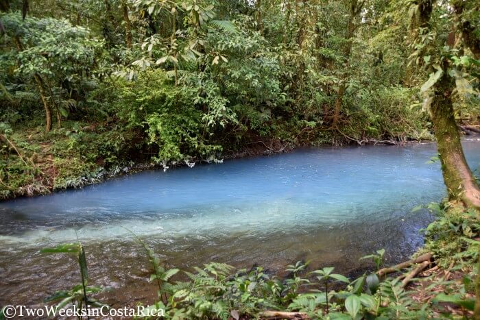
Set in the mountains in rural northwestern Costa Rica, the Rio Celeste (Blue River) and waterfall is a breathtaking natural wonder that one has to see to believe. The brilliant blue water, which seems altered at first blush, gets its show-stopping hue from a chemical reaction between volcanic minerals. A walk through Tenorio Volcano National Park will take you along the riverbed. Here, you will see (and smell) the Rio Celeste turn from clear to vivid turquoise. You will also get to admire the waterfall, which is fast becoming one of the country’s most popular attractions. Below we share the essentials for planning your visit to the Rio Celeste.
Orientation
Tenorio Volcano National Park is a lofty 31,794 acre (12,867 hectare) swath of jungle located in northwestern Costa Rica. The towns closest to the park are Bijagua to the northwest and Guatuso to the southeast. This area of Costa Rica is very rural and features verdant rolling hills, farmland, and pasture, complete with plenty of grazing cattle. If you’re looking for an authentic travel experience, be sure to spend a couple of nights in Bijagua. Because this area is more remote and has fewer amenities, it sees far fewer tourists than other parts of the country. Read our complete post Bijagua: A Gateway to the Rio Celeste Waterfall for information to help plan your visit.
Park Entrances
Tenorio Volcano National Park previously had two separate entrances: one near Bijagua and another near Guatuso. Costa Rica has since closed the Guatuso entrance, so now all visitors must enter the park from the ranger station on the Bijagua side.
See below for directions on getting to the park. We will cover the best way from La Fortuna/Arenal as well as from Bijagua and Guanacaste Province.
Trail
The hike to the Rio Celeste is moderately difficult if you go the entire length of the trail. The first section leading to the waterfall, however, is a lot easier. This is a nice option for those not interested in a strenuous hike. Below, we will describe both portions of the trail.
Here’s a link to the trail map to help you get your bearings.
Portion of Trail to Rio Celeste Waterfall
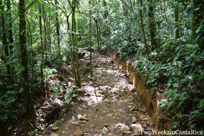
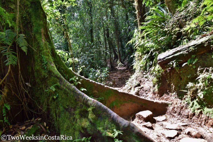
From the ranger station, the trail leading to the waterfall goes through lush forest along a nicely paved, flat path. After about 10 minutes, the pavement ends and turns to gravel, then a regular dirt trail. The hike to the waterfall is about 30 minutes in total. Along the dirt portion, you will encounter some short steep areas, a small stream crossing, and lots of roots and rocks to navigate around. This portion of the hike is fairly easy in difficulty. We passed a man with a cane and many young children.
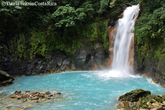
Once you reach the waterfall, it is a long 250 steps down a nicely constructed staircase to get to the viewing platform. The area around the falls is closed off and no swimming is permitted, but you will be close enough to get some amazing pictures. The Rio Celeste Waterfall is 90 meters (295 ft) tall and cascades into a deep blue pool surrounded by thick green vegetation.
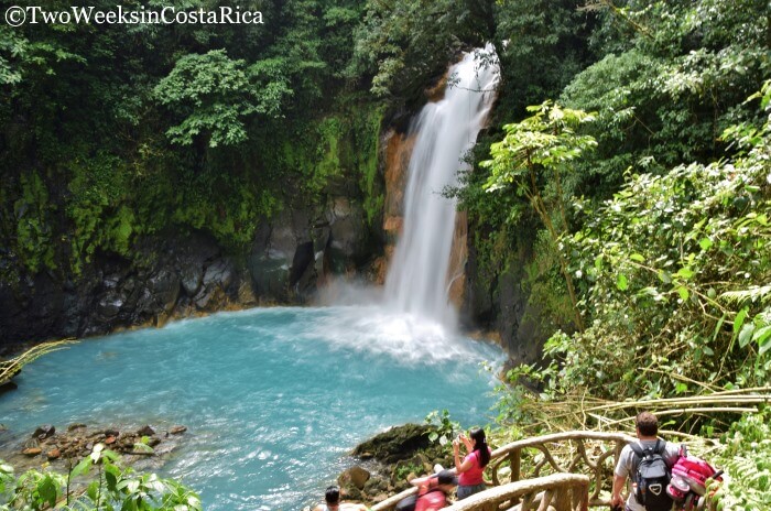
Tip: The best time to visit the Rio Celeste is during the dry season of December to April, as rain can cloud the water and dull the turquoise effect.
Portion of Trail After Waterfall
Many people turn around after they have visited the waterfall, but there are some beautiful sights if you continue on. The second portion of the hike is more difficult. From the waterfall, the trail meanders uphill before descending to the serene river. After climbing up and then down some steep inclines, around slippery tree roots and irregular terrain, you will come to the Poza Azul. This is a lovely blue pool where you will want to take plenty of photos. Note that despite some old maps and publications, swimming is no longer permitted anywhere in the park.
Continuing on, you pass over the river using a couple of small hanging bridges. Next you’ll reach one of the most interesting features of the park, the tenideros. This is the point where two rivers converge and the chemical reaction occurs. Both rivers have water that is crystal clear, but where they meet it suddenly turns a stunning blue. You might also detect a strong odor here from the chemical reaction between the sulfur and calcium carbonate, which causes the color change.
The trail dead-ends at the tenideros so you will just go back the same way you came to return to the ranger station. You can visit the park in an hour or two if you only want to see the waterfall. But if you want to see everything, allow 3 – 4 hours.
More than Only the River and Waterfall
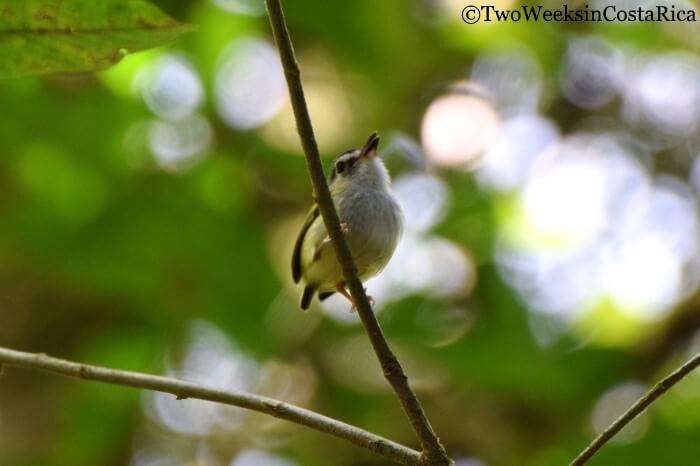
The stunning waterfall and majestic river are definitely the highlight of a visit to Tenorio Volcano National Park, but there is more to enjoy as well. The surrounding scenery is beautiful, even if you do only the short portion of the hike. Because the park is at a high elevation, it hosts primary cloud forest as well as rainforest and is home to an abundance of wildlife. On our visit, we saw white-faced monkeys, white-nosed coati (a raccoon-type animal), and many birds, including a new one for our list, the very tiny Black-capped Pygmy-Tyrant.
The longer portion also offers a scenic lookout where you can see two of Tenorio Volcano’s four peaks as well as Cerro Montezuma.
Planning Your Visit to Rio Celeste
Hours
Tenorio Volcano National Park is open daily, 8:00 a.m. to 4:00 p.m. Important: Even though the park is open until 4 p.m., last admission is at 2 p.m.
Admission
$12 for foreigners, ₡800 for citizens and residents.
What to Bring/Wear
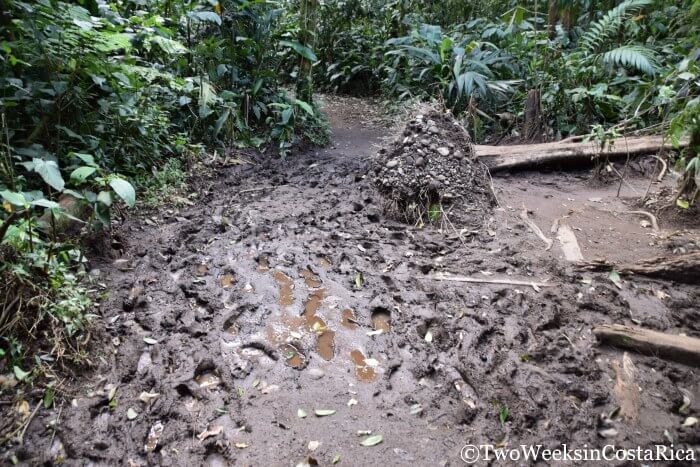
- Footwear: We recommend either hiking boots or sneakers that you don’t mind getting dirty. This area of the country receives a lot of rain so the trail is often muddy. Something like Keens would work well too.
- Clothing: Mornings can be cooler here with temperatures in the lower 70s, but it does heat up quickly. If you’re getting an early start, lightweight pants and layers are best. If you’re not starting the hike until later in the morning, shorts and tee shirts are fine.
- Water/Food: Be sure to bring plenty of water as temperatures do get hot during the day and any snacks that you may want. There are a couple of restaurants near the ranger station, but nothing else until the towns of Bijagua and Guatuso.
- For more general tips, read our post about packing your daypack for Costa Rica.
Restaurants
Right outside the park entrance are two simple restaurants serving typical Costa Rican cuisine. We ate at the one next to the ranger station and it was delicious! (Cash only)
Directions to Rio Celeste/Tenorio Volcano National Park
From Bijagua or Northern Guanacaste (Liberia, Tamarindo, etc.)
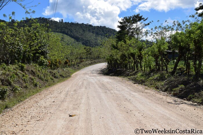
From Liberia, head south along the Inter-Americana Highway (Route 1). About 6 km (3.7 miles) before the town of Canas, take the off-ramp and go under the highway, connecting with Route 6 toward Upala. Follow Route 6 for about 22 km (13.6 miles) to Bijagua. Route 6 is a well paved road. Once you enter the small town of Bijagua, look for a sign for Tenorio Volcano National Park. Take a right onto the dirt road at the sign.
When we last visited (January 2017), they were in the process of paving the steeper parts of this road. From the main road, it took us about 30 minutes to get to the ranger station, as much of it was still rough dirt. Once the road is improved, this will be a much faster trip. 4×4 is not necessary to access the park from this direction under normal conditions.
From La Fortuna/Arenal
If you’re coming from the La Fortuna/Arenal area, it is faster to access the park from the town of Guatuso. From La Fortuna, follow Route 4 north for about 40 km (25 miles) until you get to the Rio Frio Bridge in Guatuso. Here, take your next left onto a dirt road (follow signs for the Rio Celeste Hideaway). The dirt road starts off smooth, but near the village of Rio Celeste turns a bit hilly. Parts of the steepest spots are paved, however, as you get closer to the ranger station, less of the road is paved. This could change with the improvements that are currently happening, but as of our last visit (January 2017), 4-wheel drive is recommended for this route. If you do not have 4×4, you could drive up and around the park, taking Route 4 to Route 6 and accessing the park on the Bijagua side, but this would take a lot longer.
Parking
There is parking at the ranger station for $2. Attendants will sort of watch your car, but as always in Costa Rica, do not leave anything valuable inside.
The Rio Celeste is definitely a must see for those travelers looking to check another one of Costa Rica’s natural wonders off their list. For us, this unique river and waterfall only confirmed what we already knew: that Costa Rica can keep surprising you with its magical beauty time and time again.
Post Updated: February 20, 2017
