Last Updated: April 18, 2023
Each of Costa Rica’s national parks has something different to offer. And while some feature wildlife up close or show you the power of a volcano, others are more about enjoying the raw nature around you. Tapanti National Park is one of those places. This lesser visited park gives you a feeling of exploration as you walk its trails. In this post, we will share some facts about the park, explain the hiking trails, and tell you everything else you need to know for a visit.
About Tapanti National Park
Tapanti Macizo de la Muerte National Park, or Tapanti National Park for short, is an extremely important conservation area in Costa Rica. The park is giant, protecting 144,544 acres (58,495 hectares) of land. It also abuts other conservation areas like Los Quetzales National Park and undeveloped terrain along the Talamanca mountain range. This makes it part of an important wildlife corridor.
Location
Though vast, visitors to Tapanti National Park can enter through only one main ranger station. This entrance, near the small town of Orosi, is located southeast of Costa Rica’s capital city, San Jose. Cartago is the closest large city.
The drive from San Jose to the park entrance is about 1.5-2 hours, depending on traffic. For those staying near downtown Orosi, the park is about 30 minutes away.
A Wet Environment
One thing that makes Tapanti National Park special is how wet it is. The park is situated on the eastern side of the Continental Divide. Its steep mountains catch moisture from Costa Rica’s Caribbean coast.
Each year, the area within Tapanti National Park gets anywhere from 21 to 26 feet of rain (6.4 to 7.9 meters). Yes, you read that right. Up to 26 feet of rain. Wow!
All that water makes its way down the rough terrain through 150 different rivers and streams.
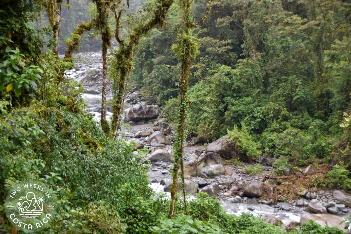
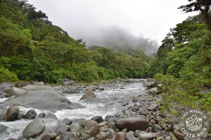
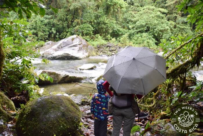
When visiting the park, you’ll be able to see one spectacular river, the Rio Grande de Orosi. This swift river flows between giant boulders and over smooth stones right past two of the park’s main trails (see Hiking Trails section, below).
Eventually some of the water from Tapanti is collected in reservoirs to supply Costa Rica’s Greater Metropolitan Area with drinking water. Five different dams within the watershed, though controversial, also help produce valuable electricity for Costa Rica.
Wildlife
Tapanti National Park has an abundance of wildlife, though it is typically not easy to see.
When hiking in the park, you’ll likely see birds, butterflies and other insects, and maybe some frogs or a snake. But more lurks within the thick forest.
The park has around 45 mammal species, including some rare or endangered ones like the Baird’s Tapir. This is Costa Rica’s largest land mammal. It looks sort of like a small hippo. They are typically very shy but have been spotted near the river, so keep a lookout. There are also deer, rabbit, otter, and big cats like pumas, jaguars, and ocelots.
If you’re into bugs, you’ll be happy to know that 2,895 insect species have been identified by scientists who study the area.
Plants
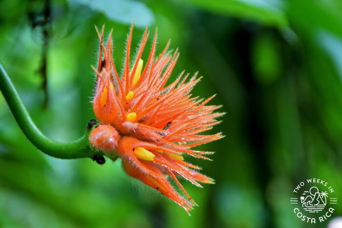
While wildlife may be harder to spot in Tapanti National Park, plants are more easily observed. A survey by Costa Rica’s National Institute of Biodiversity (INBio) identified 1,229 species of plants and 199 species of mushrooms and lichen.
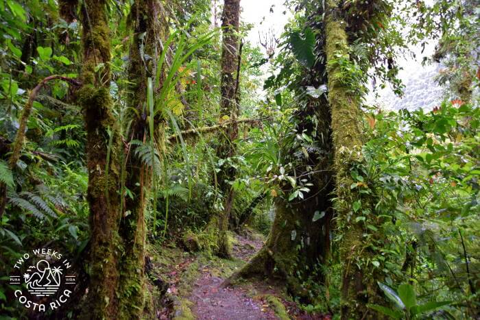
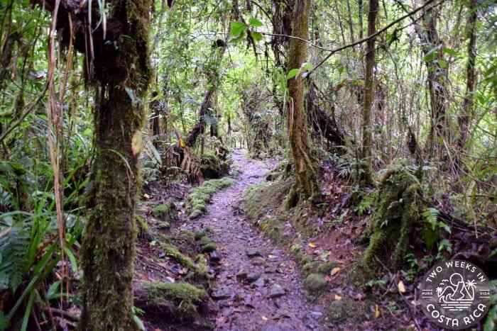
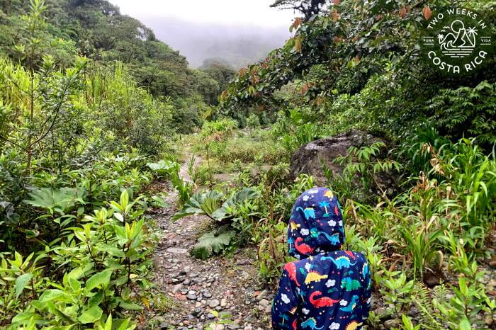
On Tapanti’s trails, you’ll enjoy lush rainforest conditions with towering trees and broad-leafed plants. With all the moisture, we noticed mosses, lichens, orchids, and bromeliads growing on just about everything.
Other areas of the park (not close to the ranger station) have completely different life zones. They include cloud forest, high-elevation montane forest (shrubby areas without trees), grasslands, swamps, and peat bogs.
Hiking Trails at Tapanti National Park
The entrance to Tapanti National Park is a little different than other parks. After passing the gate where the ranger station is located, you have two choices. You can park there and walk the main dirt road (camino principal) to the different trailheads. Or you can keep driving and park in front of each trail. Most have a parking area. It is sort of a long drive to reach the three main trails and lookout, so we would recommend parking right at each trailhead.
Here is a picture of the trail map to give you an idea.
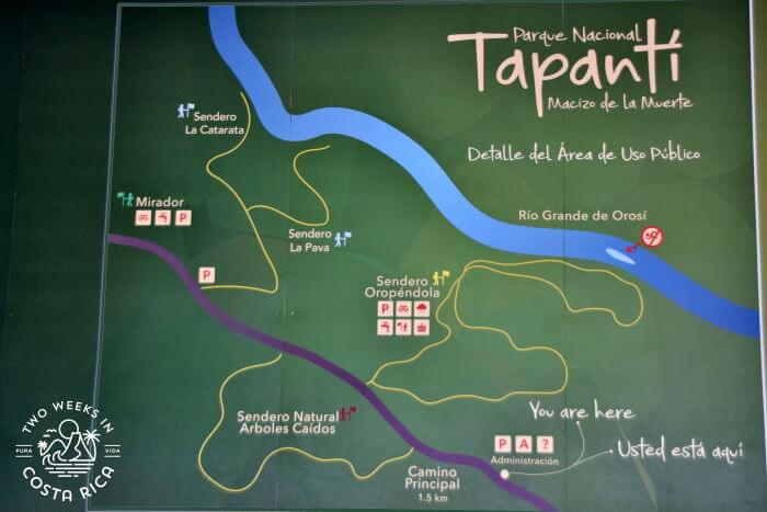
Oropendola Trail (Sendero Oropendola)
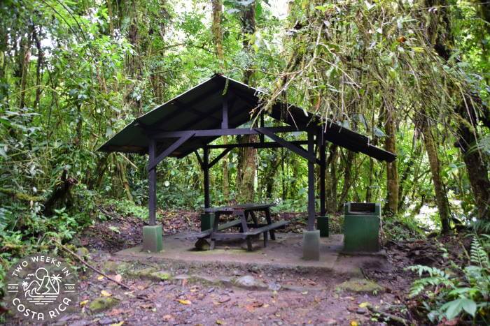
This is the easiest trail because it is the flattest, though it does slowly descend to the river with a few steeper parts. It is also the most popular because there are about a dozen covered picnic areas spread out along the river’s edge. This makes it a popular spot to picnic, especially among locals.
The Oropendola Trail is approximately 1.2 km (0.75 miles). From the parking area, it meanders down through the thick forest. In a few spots there are some simple steps to traverse. Otherwise, the trail is natural dirt and somewhat muddy in parts (depending on rainfall).
The covered “ranchitos” with picnic tables are spaced out along the last part of the trail, where it loops around in a circle. Each picnic spot has a small path leading to the river. Some have a river view, while others are set back a bit in the trees. There are freshwater faucets at each picnic area and a restroom nearby.
Waterfall Trail and Kettle Trail (Sendero La Catarata y Sendero La Pava)
This was the first trail we did, and though it says it is only 1.5 km (0.93 miles), it seemed longer, at least when doing the Waterfall Trail section. Compared to the length of the Oropendola Trail, this one seemed about twice as long and was more difficult (easy to moderate).
At the trailhead, there is a parking area with bathrooms. From there, the trail goes down somewhat steeply until it splits. To the left is the Waterfall Trail (Sendero La Catarata) and to the right is the Kettle Trail (Sendero La Pava).
The Waterfall Trail continues to go down through some wetter, swampy parts until it reaches the riverbank. Here, you can climb out near the river’s edge along the many rocks.
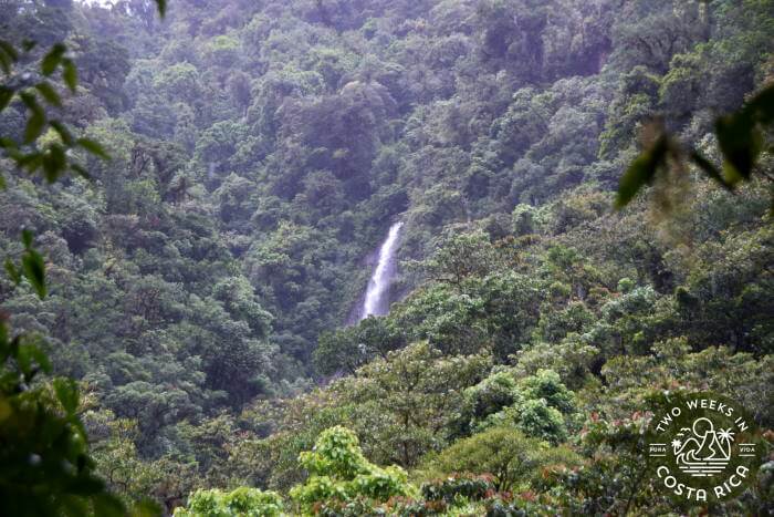
On the other side of the river, up on the mountainside, you will see a giant waterfall in the distance. You can continue up the river’s edge to get a better view of it (depending on river conditions), but be careful as the rocks can be slippery. We saw one family slip, and their young son hit his head on a rock. He was okay but it was scary.
The Kettle Trail is the short path to the right where the main trail splits. It zigzags down one steep section of uneven steps and then leads to the river’s edge. When we were there, we had to cross a large puddle of water at the bottom by jumping from stone to stone. Conditions likely change throughout the year.
This part of the riverbank was a bit more sandy and easier to explore. Our young kids had fun running around and checking the puddles for frog eggs.
Fallen Trees Trail (Sendero Arboles Caidos)
The Fallen Trees Trail is the hardest of the three trails. It is around 3 km (1.86 miles). From the main road, it climbs a steep hill before looping back down to the road, exiting in a different spot.
We did not attempt this trail with our little kids (5 & 2 at the time) because the ranger told us it was difficult and very muddy. If you try it, we’d love to hear your report in the comments below.
The Fallen Trees Trail doesn’t have its own parking area but starts near the Oropendola Trail, so you can park there.
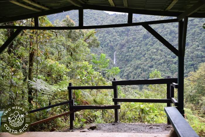
Waterfall Lookout (Mirador de la Cascada)
Lastly, there is the Lookout at the end of the park’s main road. This is definitely worth a stop and doesn’t take much time. From here you have a better, though still distant, view of the same waterfall that you could see at the bottom of the Waterfall Trail. You also can appreciate the grandeur of the park with its undeveloped green mountains as a backdrop.
At the parking area for the lookout, there are four covered picnic tables and a restroom. From there, a set of steps climbs up to the lookout platform (also covered in case of rain). The steps/trail is only about 100 meters (330 feet), but it is steep and can be slippery.
Buying Tickets for Tapanti National Park
Currently, you must purchase tickets online in advance to enter the park. Keep in mind that there is no cell phone service at the park so you will need to purchase them online in advance.
To get your tickets to Tapanti National Park, you must first create an account on the SINAC government website.
Once you are logged in, click “Buy” and select “Online Reservation.”
Next choose the wildlife area,“Parque Nacional Tapanti Macizo de la Muerte.”
Choose the date you plan to visit, and select the number of adults/children.
Click “Continue.” You will be taken to a payment screen to enter your credit card details (you have 10 minutes to complete the transaction).
Once you complete the transaction, a confirmation will be emailed to you. Keep this to show the park ranger when entering the park. They will need the verification number off the reservation to look you up in the system. Again, there is no cell phone service near the park so be sure to load your email with the tickets before arriving.
Park Hours
Tapanti National Park is open every day (including holidays) from 8:00 a.m. to 4:00 p.m. The last entrance is at 3:00 p.m.
Cost
Foreigners: $10 per person adults. $5 children ages 2-12. Free for children 2 and under.
Citizens and Residents: 800 colones adults. 500 colones children ages 2-12. Free for children 2 and under. Valid identification required when checking into the park.
Accessibility
The park’s trails and lookout are not handicap accessible. The main road through the park, however, is flat and can be used for nature exploration. It is forested on both sides. The picnic tables near the Lookout are accessible without going up any steps, but the bathroom is up a steep incline. A bathroom at ground level is available a short distance away at the start of the Waterfall and Kettle Trail.
Tips for Visiting Tapanti National Park
What to Bring
Be sure to bring a raincoat and/or umbrella since it can rain on and off at any time. A rain cover for your day pack and dry bag for your electronics is also helpful in case of a downpour.
Sturdy, closed-toe footwear is recommended since the trails can be wet and muddy.
Temperatures are cooler so lightweight hiking pants and a raincoat or long sleeve shirt are nice to have.
For more information on what to bring, read our post, 10 Day Pack Essentials for Costa Rica.
Other Tips
Swimming is not allowed in the river.
There is no cell phone service so turn on airplane mode to save your battery.
There are no trash cans at the picnic areas. Be sure to hike out with any trash you have.
Conclusion
We really enjoyed our visit to Tapanti National Park. From the plants growing on top of plants to the swift river and giant boulders, it gave us a true feeling of being surrounded by pure nature. We hope this post helps you experience it for yourself.
Have a question about visiting Tapanti National Park or have you been yourself? Let us know in the comments below.
Some of the links in this post are connected to affiliate programs we have joined. As an Amazon Associate we earn from qualifying purchases.
Looking for more less-visited parks? Check out these posts:
Orosi: A Valley of Green – The small town of Orosi makes an excellent jumping-off point for exploring Tapanti National Park. Learn more about this area with this post.
Los Quetzales National Park: Costa Rica’s Other Cloud Forest – This park borders Tapanti but is at a higher elevation in the cloud forest.
Cabo Blanco Nature Reserve: Rugged Hiking on the Nicoya Peninsula – On the southern tip of the Nicoya Peninsula, Cabo Blanco was one of Costa Rica’s first parks. It has a challenging hike to a remote beach.
Lomas Barbudal Biological Reserve: An Oasis of Green in Guanacaste – If you are looking for a park without many visitors in Guanacaste, this is your spot.
