Last Updated: March 13, 2023
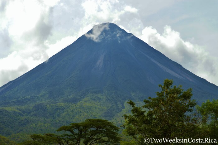
Early one morning in July 1968, an unassuming green mountain in northern Costa Rica suddenly awoke and became the legendary Arenal Volcano. If you are visiting the town of La Fortuna, you’ll be able to get a close up of Arenal’s now ashy gray peak from many different spots. One place of particular interest is the Arenal 1968 Trail. This series of hiking trails brings you through forested areas and across some of the historic lava fields that buried much of the surrounding jungle during the dramatic eruptions of 1968. In this post, we’ll give you all the details you need to plan your visit to Arenal 1968.
Location and Access
Arenal Volcano is located about 3 hours from the main airport in San Jose and about the same distance from the smaller international airport in Liberia. The closest major destination is La Fortuna.
Access to the 1968 Trail is about 25 minutes from La Fortuna on the western side of the volcano. From the downtown, you take Route 142 west towards Lake Arenal and then a left onto the dirt road leading to Arenal Volcano National Park and El Castillo. About 1.25 km (3/4 of a mile) down the road, you will find the visitors’ center and parking area for the 1968 Trail. The property is marked with a big sign on the left so you can’t miss it.
Admission is $25 per person for a self-guided visit.
Tip: The dirt road getting to the 1968 Trail is flat and bumpy, but a 4-wheel drive vehicle is not necessary. If you need a car, rent one from Adobe Rent a Car in downtown La Fortuna and make sure to use our Discount page to save some money.
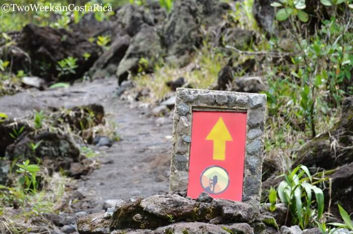
The Trails at Arenal 1968
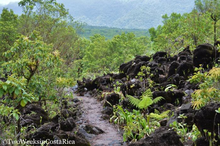
The big draw of the Arenal 1968 Trail is the fairly close views of Arenal Volcano. These views give you a look at the old lava flows, now hardened into rock, coming down the slope of the volcano and into the valley. On the edge of the lava field are also a lot of different sized volcanic boulders scattered around. It’s crazy to think about, but these rocks were shot into the air during eruptions at speeds of up to 2,000 km (1,200 miles) per hour. One large rock even left a sizable crater that you can see on the trail. To get to these features, there are a couple of ways to go.
Here is a link to the trail map.
The Bosque 1968 Trail
This trail (the Forest Trail) sets out through some fields and into the thick forest before climbing up to the lava fields and viewpoint. Along the way, it passes Lago Los Patos or Duck Lake, which is about 22 meters (72 feet) deep and was formed when the eruptions took place.
This trail is 4.7 km (3 miles) long and is a moderate-to-difficult hike since the terrain has some steep portions as well as lots of roots and rocks. It’s well worth it, though, if you are looking for birds and other wildlife, since there is a lot hiding in the shade of the forest and around the small lake.
The Colada 1968 Trail
Another way to reach the viewpoint and lava fields is to take the Colada Trail. This is a slightly shorter trail at 4 km (2.4 miles) and is strenuous at times but not as difficult as the Bosque Trail.
Colada translates to wash or flow, and this trail is so named because it has the best views of the 1968 flows and the volcano.
Note: All hiking trails around Arenal Volcano are limited to areas surrounding the base for safety reasons. Although there hasn’t been any major activity since 2010, the volcano is still considered active and is known to release toxic gases and hot steam near the summit.
What You’ll See
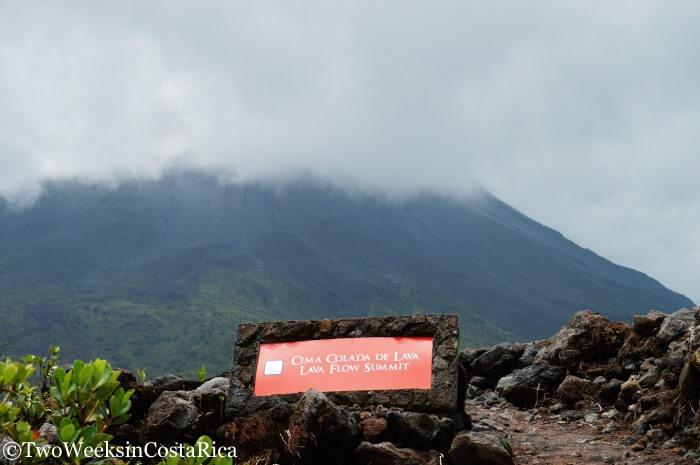
No matter which trail you take, the good news is that you will end up at the same viewpoints since both trails overlap in the middle. From the highest point, at the Lava Flow Summit, you can normally get a spectacular view of Arenal Volcano. Unfortunately, it became clouded over right as we arrived but we were still able to see parts of it as we hiked.
Tip: It’s not uncommon for the top of the volcano to be clouded over due to local weather conditions. The Arenal area has slightly different weather patterns so it is generally the most rainy during the dry season on the Pacific slope (December to April). Many people say that the best times to see the volcano are September and October. We have found from many visits to Arenal that it really just depends, and conditions can change from one minute to the next.
During our visit, we hiked the Bosque Trail since our good friend Harris, a serious hiker, was with us. We all really enjoyed this trail, mostly because of the flora and fauna that we spotted, but also because it was a great workout.
Some of the things we saw were lots of birds, including the Magpie Jay, Tropical King Bird, Montezuma Oropendola, Thick-billed Seed Finch, and an Anhinga in the small lake. We also saw some cool insects like butterflies, leaf-cutter ants, gigantic blue bumble bees, and this crazy beetle.

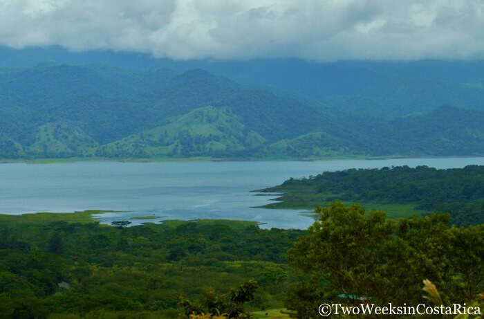
Near the lava flow and volcano viewing area, we also took in a nice view of Lake Arenal to the west. This is Costa Rica’s largest lake but wasn’t always that way. In 1979, Costa Rica’s electric company built a new hydroelectric dam that tripled the lake’s size. In the process, two towns (Arenal and Tronadora) were relocated to higher ground. To this day, remnants of those old roads and buildings are still at the bottom of the lake.
The 1968 Trail is an amazing place to hike and learn more about the mighty Arenal Volcano’s ferocious history. Imagine what it was like that historic day back in 1968 when a mountain literally blew its top and released its fury on the nearby jungle and farms. Altogether, 73 people lost their lives in the tragic eruptions reminding us that Mother Nature rules all.
Last Updated: March 13, 2023
Have you hiked the 1968 Trails near Arenal Volcano? Let us know what you thought in the comments below.
Looking for more to do in the area? Check out these posts:
La Fortuna: What to Expect from Costa Rica’s Most Popular Destination – There is so much to see and do around La Fortuna and that’s why most visitors stop here at least for a few nights. Read this post for our hotel, restaurant, and activity recommendations.
Hiking in Arenal National Park – Located right next to the 1968 Trail, this national park has many of the same features including lava flows, volcanic rocks, and a nice view of Lake Arenal.
Rio Celeste Waterfall – One of Costa Rica’s most beautiful waterfalls is only a day trip away from La Fortuna. Read this article to learn about the hike to the bright blue Rio Celeste.


Hi!
Is it possible to do the Bosque 1968 Trail (lava trail) and the Cerro chato trail in the same day?
Thank you!!
Hi Alexandra, It is possible to do both, but because the Cerro Chato hike is rigorous, we wouldn’t recommend it. You will probably enjoy it a lot more if you break them up into two days. In case you haven’t seen it, here’s a link to our post on Cerro Chato, with info on trail conditions.
Hey guys! In your opinion, which hiking has the best lava flow trails: 1968 trails or the national park? We are going to do one or the other either tomorrow or Monday:) Thanks!
Hi Kelli! Both have areas with lava flows but they are more extensive at the 1968 trails so we would say to go with that. One of the trails there is covered with old rocks from the big eruption and we think the view of the volcano is a bit closer. Hope you can see the volcano! Let us know how it goes if you have a chance.
On the Forest Trail
What were the wooden boxes on posts?
What is the story about the herbs and pineapple plants in a large cultivated area.
Hi,
Wondering if we need to book tours to hike Arenal and Manuel Antonio or if we can hike on our own. Also interested in hot springs around the volcano and a day trip to Nicaragua. Any suggestions on where to book?
Thank you!
Hi Patty, You definitely don’t need to book tours to hike either Arenal or Manuel Antonio National Parks. You can arrange your own transportation, pay admission with the park ranger, and explore the trails self guided with the trail maps they provide. Both have well maintained paths that are easy to follow. That said, guides can be nice to have because you will learn about the local flora and fauna and probably see more wildlife too. It’s a good idea to hire a guide early on in your trip to familiarize yourself with hiking in Costa Rica, but once you get the hang of it and know what to look for, a guide becomes less necessary.
For hot springs, people like Tabacon, which is one of the larger resorts with well manicured gardens and several pools. For something smaller, more intimate, and usually less busy, there’s Ecothermales.
We have only traveled to Nicaragua independently so aren’t sure of a tour company to recommend. If you end up having a good experience with one, we’d love to hear more about it so we can recommend it to others. Enjoy your trip!
Hello, how are you ?
I would like to know from you what the conditions of the roads to the main tourist cities, for example, from San Jose to Fortuna (Arenal), Tamarindo (Pacific) and Limón (Caribbean).
My question is if I should rent a 4×4 vehicle (very expensive) or a more conventional model.
Greetings.
Hi Junior, We have general information about where you need 4×4 in the FAQs of our rental car discount page. We also have a very detailed post that describes the conditions on all of the major roads in Costa Rica. That post should give you a good idea on if you can rent a regular car for where you’re going. Here’s the link.
Hello your story of Costa Rica’s Arenal but back such good memories. In 1980 my husband,another couple and myself hired a taxi in Sanjose for the trip up to the mountain. He would not drive to close so we hiked half way up the face of the mountain. It was amazing. Their was a tin shack part way up and when the mountain started to rumble and throw stones we ran for the shack. I don’t know when I felt so afraid but It was so incredible, the sheer wonder of the experience. Our driver thought we were all crazy, and looking back as a women over 70 now I guess we were, but such memories of an amazing country. Linda
Wow, Linda, that is quite a story! I would have been scared too. The volcano isn’t spitting stones or lava anymore (it’s still considered active but hasn’t done much in years). We never got to see it when it was active, but it looked incredible, especially the pictures of the lava glowing red at night. Don’t think I would have wanted to be as close as you though, haha. Thanks for sharing your experience.
So access to these trails are outside the National Park?
Hi Susie, Yes, although the Arenal 1968 Trail is right next to the national park, it is a private reserve that is completely separate.
Can we do these hikes without booking a tour? We plan on taking a night away from our rental property and spending it in La Fortuna. We hope to get some hiking in and sightseeing while we are there at our own pace. Thanks for you advice! I have enjoyed reading about your experiences:)
Hi Naomi, Yes, you can certainly do this hike self-guided and would just need to pay the entrance fee ($15) to get in. We usually recommend a guide to get the most out of your visit since there is no visitors center or information along the trail, and also to see more wildlife and learn about the local flora and fauna. But it’s still a nice hike on your own and the trail is well marked and easy to follow. Have a nice visit!
Hi Guys,
Are the hiking trails easy to navigate through alone? How much would it cost for a guide?
Hi Baz, The trails are well marked and fine to do on your own. You can ask for a trail map when you pay. The reason we suggest a guide is so that you get more out of the experience, not for the logistics of the hike itself. The cost for a guide is around $56 per person for a 3-hour tour. This includes round-trip transportation from your hotel, entrance fee, and water. Let us know if you would like us to set you up with someone.
Hello
I’m also interested in a guide for hiking at Arenal (as well at Rainmaker).
And last question: Which hanging bridges do you recommend? Thanks!
Hi Elli, We just sent you an email. Thanks!
Hello, I send you a comment yesterday, but I do not see it posted yet. Not sure if it’s not processed yet or it didn’t go through. Anyway, I talked to my family yesterday, and we definitely want a local guide to take us on the 1968 Trail. Please advise.
Hi Nikoleta, We have received your comment and we will send an e-mail with more information shortly!
Hi Jenn and Matt,
thanks for your posts, I find them very useful while planning my own Costa Rica experience. We have 4 nights at Arenal and I’m now deciding on which tours/activities to do there. What would you recommend; doing the 1986 trail you describe above or Sendero Las Coladas trail (1992 flow trail) you describe in another post? In terms of duartion/difficulty and elevation which trail is easier? On the other hand, which one, you believe gives a better expoerience?
I also read a lot about Arenal Observatory lodge trails – how much time does that one take?
If we had to choose 1 hike, which would you recommend? We are big nature fans, but my husband is not so keen on long, high ascend hikes 🙂 Thank you!
Kind regards!
Hi Tjaša, The 1968 Trail is slightly harder than the national park. The main trail at the national park that takes you near the lava flows is all flat except for the short portion that brings you up the lava flows to the lookout for Arenal Volcano. So maybe the national park would be better for you. Both are great experiences. The Observatory does have trails but they are more limited now that access to Cerro Chato is closed so we would do the national park or 1968 Trail. Let us know if you’d like our recommendation for a guide. We’d be happy to help you with the arrangements.
Hi there,
This hike sounds beautiful! But with limited time and budget, and everything with an entrance fee of $15/per, we’re hoping to combine activities as economically as possible. I’ve found several tours offering La Fortuna waterfall, Arenal NP, and hanging bridges walk. Are all these features found within the national park? Or are all the hanging bridges to be found at Mistico?
Thanks in advance!
Be
Hi Be, Mistico and Sky Adventures are the only places in the Arenal area with hanging bridges. The 1968 Trail is just hiking, but it has the best view of the volcano. You can save some money by doing La Fortuna Waterfall on your own. Then you will just have to pay the admission fee.
Hey Matt!
I am visiting Costa Rica in a couple weeks and trying to decide between the Bosque – 1968 , or a combination of Las Coladas y El Ciebo trail in the National Park. I’m an experienced hiker and am wondering which is better! I have two full days in La Fortuna, and plan to do this one day, and the Waterfall the other. Was wondering what else is a must see – the Hanging Bridges? Are they similar to Monteverde Cloud Forest? Thanks so much in advance!
Peyton
Hi Peyton, The 1968 Trail is a little more challenging so we would go with that over the national park. Hanging bridges are definitely a must see in either La Fortuna or Monteverde. Both offer a great experience and have options for elaborate hanging bridges so we’d recommend doing them wherever it makes the most sense with your schedule.
Hello. We will be in Costa Rica a month from now. We have booked a hotel in La Fortuna for 4 nights. Our teenager studies geosystems at school and expressed a wish to visit a volcano. I read that access to Arenal is restricted, but I still think it will be worth a trip. There will be three people in our party, all in good physical shape, and because this is an educational trip, I think an English-speaking guide with a good local historical, geological, and flora/fauna knowledge would be an added benefit. I think The 1968 Trail is probably what we would like to do. Do you think it is a good idea for a day trip in early July? Thank you.
Can I drive my personal car to The Arenal 1968 Reserve or the Arenal Volcano National Park and park there while I hike the trails?
Thanks for all the information.
Hi Bhavin, Yes, of course. You can self drive and just park in the lots. You don’t have to go with a tour company. Just don’t leave any valuables in the car, as always in Costa Rica.
Hi there!
We are planning a trip to La Fortuna in a few weeks and trying to organize our plans. We have an 18-month old daughter who we hike with in a hiking backpack. Are there any particular hikes you would recommend with a child or would they all be good? Please feel free to let us know any good activities for a child that young (she’s very easy-going and inquisitive).
Thanks,
Jen
Hi Jen, You should check out our post all about Activities in La Fortuna with Young Children. It has several different options.
I just returned from Costa Rica and your site was a huge help. I just wanted to let you know that the price of the 1968 trail is now $25. So you may want to update your info above.
Thanks for letting us know, Mike! We just updated our article.
We will be in the area for 2 days -24-25 July.
Is there any point hiking the volcano 1968 trail at that time?
I am worried that even if it is not raining at that time the trail might be too muddy and impassable.
Really appreciate your expert opinion
Thanks
Hi Ulka, La Fortuna/Arenal has different weather from the rest of the country. Typically late July is a good time to see the volcano as it is drier. People who live in that area actually often say that Sept./Oct. is the best time to see it, which is peak rainy season in other parts of the country.
Hello, Can you give me an idea about the time that the trails take? Thank You 🙂
Hi Henk, We would plan to spend 3 hours or so to hike all the trails. Enjoy!
Hi – we are going to Costa Rica and bringing my 80 year old mother. We are interested in doing the Colada 1968 trail. If we only did the first 2 miles, would that still give us a great experience and how difficult are the first two miles? Thx
Hi Ilene, Yes, you would still have a really nice experience if you did only the Colada Trail. It’s 2.4 miles total. Even that does have some steeper parts, though. If you wanted something flatter, Arenal Volcano National Park is a good option.